
![]()
![]()
![]()
![]()
![]()
![]()
![]()
![]()
![]()
![]()
![]()
![]()
![]()
![]()
![]()
![]()
![]()
![]()
![]()
![]()
![]()
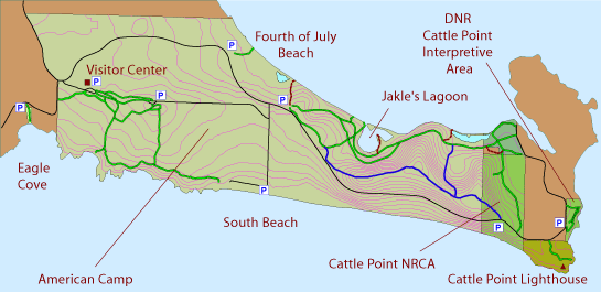
At the Southeast end of the island the National Park Service and the State Department of Natural Resources (DNR) provide a network of trails.
| American Camp |
| Restrooms at the Visitor Center, South Beach, and 4th of July Beach |
| Potable water at the Visitor Center |
| 9 miles of trails |
| Parking is available at numerous locations |
| Dogs must be on leash |
| Picnic tables |
| Slide Show: Click here |
| Website: www.nps.gov/sajh |
With Mileage Without mileage (Requires FREE Adobe Acrobat) Get Acrobat Here |
The trails through the woods once ended at private property near the east end, but that land has now been purchased by the Land Bank and the DNR, and it is possible to walk all the way to Fish Creek.
Adjoining land at the east end of the national park, once private property, is now managed by the State DNR as the Cattle Point NRCA (Natural Resources Conservation Area). Parts of it are owned by the DNR, the Land Bank, the BLM, and the Coast Guard, but together with the National Park it provides a seamless network of trails.
Funding for these maps was provided by San Juan Island Park & Recreation District, locally known as Island Rec.
The maps were created by San Juan County Public Works and volunteers from the Trails Committee.
![]()